Færsluflokkur: Ferðalög
10.7.2011 | 23:33
Saturday 9th – a day of difficulties
We started our morning with minor repairs and were on our bikes at 11. The wind was blowing strongly in our face and the road was very bat. We had many difficult hills to climb and the road surface was very rough. Many of the hills were simply not bikable so we had to walk up with our bikes. We made slow progress and the dust was bad when trucks and cars past us. Through the course of the day we however crossed the water divide of Iceland. At one point in time the rivers were flowing to the south and then they were flowing to the north. We also crossed the half way point of this road. To add on to all this were mechanical problems. Gudjons seat came loose and the bracket on the back of my bike (where I hook on the bags) came loose and I lost the screw. I have many loose ones in my had so I was able to replace it but all this took time. I am however very pleased with how will the bikes are standing up to this wear and tear. The statistics for the trip is as follows: We were moving for 6 h and 43 m and stopped for 2h and 15m. Max sped was 27 km/h but the moving average was 6,9 km/h but the overall average was 5,2 km/h. Our max elevation was 704 m.a.s.l. and our total ascent was 753 m which shows how hilly the terrain was that we travelled through. These are the worst roads that I have ever biked.
Ferðalög | Slóð | Facebook | Athugasemdir (1)
10.7.2011 | 23:31
Friday July 8th - The first day a good success
Friday July 8th - The first day a good success
We had a later start on the day than planned and departed on our bikes from Gullfoss at 12:20 instead of 9:00 AM as originally intended. The weather was very good clods at the beginning but it cleared up as the day progressed. The wind was against us but it was not strong so it did not play a role. The first 15 km were paved but we were in for a shock when we entered the gravel road or should I say the sand road. For some reason the Road Authorities had used sand to fill the potholes a very futile process since the wind blows it away in a matter of days. There was no way we could cycle in this material. I saw a look of despair in my sons face. Is this what awaits us? Fortunately the part was only 3-4 km after that the road became harder but pretty rough. Then the obstacle of the day – Bláfellsháls. We had to climb 313 meters over this mountain pass but the road was excellent and the weather good. The road was good all the way to Hvítá river but the last 15 km were on rough roads. The statistics for the day are: we biked 43,95 km in 4 hours and 40 minutes which gives the average speed of 9,3 km/h. We rested for 1 hour and 25 minutes and our maximum speed was 33,8 km/h. Greatest elevation was 620 m.a.s.l and our total ascent was 581 m.Ferðalög | Slóð | Facebook | Athugasemdir (0)
8.7.2011 | 01:54
Packed and ready to go!
I have finished packing for the bike trip. Each of us has two 20 litre (at the back) and two 10 litre bags (at the front) in addition to the tents and sleeping bags which we place on the back bracket of the bicycles. I did not way the bags but I do have the feeling that they are a little bit on the heavier side. Once we reach N-Iceland we will have an opportunity to review our loading. Then we will have some sense of what we need and what we do not need. This is however less weight then I had on my trips previously. My only worry is that the bike may break down. We have the usual spear parts (chains, tubes, tires etc.) but we are not equipped for any major breakdowns. The weather forecast is good but the wind will be against us but it will not be a strong one. The nights will also be cold. Once we start biking back (to the south) the winds are forecasted to changes and will therefore be in our face again. Oh well, you can’t win them all!
Ferðalög | Slóð | Facebook | Athugasemdir (1)
7.7.2011 | 18:34
Tal - fyrirtæki með einstaklega lágt þjónustustig
Ferðalög | Breytt s.d. kl. 18:36 | Slóð | Facebook | Athugasemdir (0)
1.12.2010 | 13:15
01.12.2010 The bike trip next summer – Hjólaferðin næsta sumar

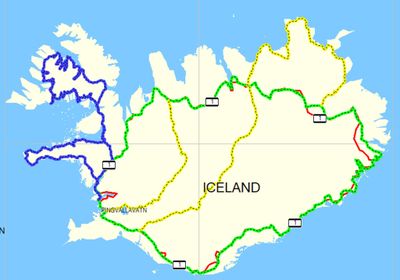 Planning for next summer’s trip is well under way. The idea is to bike the interior and a part of NE-Iceland that I did not bike when I did the circle road in 2009. The map shows my route around Iceland in 2009 (green line), my trip around the western part of Iceland in 2010 (blue line) and the intended trip through the interior and back next summer (yellow line). The circle road was 1400 km, the west fjords 1100 km and I estimate that the trip next summer will be between 900-1000 km. This is however on mountain roads with unabridged glacial rivers and more extreme weather conditions. I will not be pulling the trailer but instead I will load all the gear on the bike. This means that I need to lose more weight than previously and this will also call for a stronger mountain bike. I am not sure if I will have time to do this in one go since my son will be joining me and he has a demanding schedule next summer. So we might do this in three legs. I have already started the preparations by hiking every weekend and swimming daily. In the past two weeks I have taken of 3-4 kg. Think I have another 20 kg to go.
Skipulagning fyrir hjólatúr næsta sumars er hafin. Nú er hugsunin að hjóla hálendið þ.e.a.s. hjóla norður Kjöl, síðan fyrir Melrakkasléttuna og til baka Sprengisand. Kortið sýnir leið mína hringinn sumarið 2009 (græna línan), Vestfirðina og Snæfellsnes í sumar (blá línan) og fyrirhugaða ferð næsta sumar (gula línan). Hringurinn var 1400 km, Vesturlandið 1100 km og hálendið og NA-land áætlað 900-1000 km. Þetta eru náttúrulega hálendisvegir með óbrúaðar jökulár og allra veðra von, sérstaklega fyrri og seinni part sumars. Nú verður kerran góða ekki með í för heldur verður farangur allur borinn á hjólinu. Þetta þýðir að ég verð að vera léttari í byrjun ferðar en í hinum tveimur auk þess sem ég verð að fá mér kröftugt fjallahjól. Líklega geri ég þetta ekki í einum rykk þar sem sonur minn kemur með og hann er nokkuð önnum kafinn í vinnu og öðru í sumar. Líklega verða þetta tveir til þrír leggir t.d. Kjölur svo Melrakkasléttan og síðan Sprengisandur. Þetta skýrist þó þegar fram líða stundir. Ég er þegar byrjaður að koma mér í form. Búinn að ganga á fjöll undanfarnar helgar og farinn að synda daglega enda 3-4 kg farin og þá eru bara 20 kg eftir. Gæti verið erfið jól.
Ferðalög | Breytt s.d. kl. 13:20 | Slóð | Facebook | Athugasemdir (0)
12.7.2010 | 22:28
The last day of biking was a good one – Síðasti dagur ferðar var góður
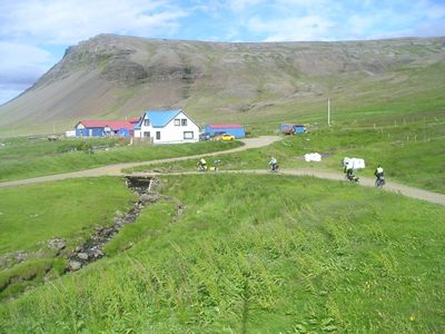 The last day of biking was a good one. We woke up early and had the best breakfast of the trip. In fact I want to state that this is the best breakfast I have had in any Icelandic hotel and I have had breakfast in most of them being a guide in the summertime. The wind blew us towards Borgarnes and the sun was out. We did have one very heavy shower just before we entered Borgarnes which left all three of us soaked to the bones. I was hoping that we would do the last 30 km to the tunnel before the weekend traffic would start back to Reykjavík which on a normal Sunday is around 4-5 PM. One big miscalculation was that they were showing the final game of the World Championship in football on TV in the evening and many had taken an early start to be able to catch the game so traffic was very bad but we survived. I took us about 4 hours and 45 min to bike the 84 km we did on this day.
I have calculated the statistic for the whole trip based on my GPS measurements. Of the four that took part I am the only one that biked all the way. In all I biked 1110,4 km in 15 d (two additional days were taken off). I was moving on the bike for 95 hours these 15 days. It is interesting to compare this to last summer when I biked 1400 km in 96 hours! The mountain passes obviously slow you down. My average speed for the trip was 11,7 km/h and the total ascent was 12036 m! For those that do not understand what that means the simple explanation is that the GPS ads to gather all the legs of the trip were we have an increase in elevation. A low value means that you are riding in flat terrain but a big value means that you are going continuously up and down. In short I biked up Hvannadalshnúk, Iceland’s highest mountain (2110 m.a.b.s.l.) six times in these 15 days or Mt,. Everest 1,5 times! Not bad. The statics for each member of the group is below. I will be posting pictures from the trip in some of the coming days. I have included the only picture that I have of all four of us on the bikes. Taken at Rauðsdal.
Name | Distance | Hours | Av. Speed | Total ascent |
Kristinn | 1110,4 km | 95 | 11,7 km/h | 12036 m |
Thelma | 964,4 km | 76,4 | 12,61 km/h | 10736 m |
Lárus | 674,8 km | 62,5 | 10,8 km/h | 8341 m |
MaryAnne | 551,6 km | 43,6 | 12,7 km/h | 6543 m |
Síðasti dagur hjólaferðarinnar var góður. Við vöknuðum snemma og fengum okkur besta morgunmat ferðarinnar að Hóteli Eldborg (Laugagerðisskóli). Ég hef reyndar starfað við leiðsögn undanfarin sumur og hef fengið morgunverð á mörgum hótelum og leifi mér að fullyrða að hvergi er hann jafn vel úti látinn í tegundum og gæðum. Vindurinn bar okkur á vængjum sínum til Borgarness en við fengum að vísu eina blauta góðvirðisskúr rétt áður en við náðum Borgarnesi. Að örðu leiti var veðrið bjart og fagurt. Ég var að vona að við slyppum við helgar umferðina frá Borgarnesi að göngum en gleymdi að reikna með því að úrslitaleikurinn í HM var sýndur síðdegis og margir flýttu því för sinni. Umferðin var þung og erfitt að hjóla þessa síðustu 30 km. Það tók okkur 4 tíma og 45 mín að hjóla þessa 84 km.
Ég er búinn að taka saman tölfræðina fyrir ferðina eins og hún var skráð af GPS tækinu. Útkoman fyrir hvern og einn er sýnd í töflu hér fyrir ofan. Ég er sá eini sem hjólaði alla leið alls 1110,4 km á 95 tímum (15 dögum). Það er athyglisvert að það tók mig 96 tíma (á 16 dögum) að hjóla hringinn 1400 km í fyrra. Svo hægja heiðar og hálsar á manni. Meðalhraði minn var 11,7 km/h en var ef ég man rétt um 16 km/h í fyrra. Það sem er athyglisverðari er að heildarhækkun mín er 12036 m. Fyrir þá sem ekki vita þá þýðir það að tækið leggur saman alla hækkun sem verður á leiðinni. Á flötum vegi er þetta venjulega lág tala en öldóttum há. Ég hjólaði sem sé á þessum 15 dögum 6 sinnum upp á Hvannadalshnúk! eða einum og hálfum sinnum á Evrest! Ég mun setja inn myndir frá ferðinni á næstu dögum. Læt hér fylgja einu myndina sem er til af okkur öllum fjórum á hjóli tekin við Rauðsdal á Barðaströnd.
Ferðalög | Breytt 13.7.2010 kl. 02:24 | Slóð | Facebook | Athugasemdir (0)
9.7.2010 | 22:43
Journey to the Centre of the Earth – Ferðin að iðrum jarðar
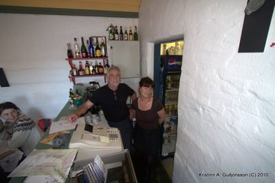 I started the day by going to the dentist in Ólafsvík. I lost a filling the other day and the tooth was bothering me. I return to my brothers house around noon and had some of Láras fantastic fish soup for lunch. We started our trip around 13:00. This was a much brighter day than many of the previous ones and I even decided to were shorts today. We had the wind in our back as we circled Snæfellsnesglacier (if you have read Juls Vernes book “Journey to the Centre of the Earth” than you know it was in that glacier they started their descent into the earth’s centre). At one point I reached a speed of 45 km/h without peddling! So strong was the tail wind. But we paid for that luxury as we came around the glacier the fantastic tail wind became a horrific head wind. It took us as long to cycle the last 10 km as it had taken us to cycle the first 40 km. In all we cycled 51 km in 4 hours.
Ég byrjaði daginn á því að fara til tannlæknis á Ólafsvík enda hafði ég tapað fyllingu deginum áður. Kom aftur til bróður míns um hádegi og við gæddum okkur á afgöngunum af hinni frábæru fiskisúpu hennar Láru. Lögðum í hann klukkan 13 og var nú veður bjartara en verið hefur marga undanfarna daga. Ég ákvað t.d. að hjóla í stuttbuxum í dag og er það í fyrsta sinn í þessari ferð. Athyglisvert að í fyrra þegar ég hjólaði hringinn á sama tíma árs var ég alltaf í stuttbuxum – fór held ég þrjá daga í síðbuxur. Við vorum með beggja skauta byr. Mér tókst að ná 45 km/h hraða án þess að stíga hjólið! En okkur hefndist fyrir þetta því þegar kom fyrir jökulinn var þessi frábæri meðbyr að ferlegum mótvindi. Enn og aftur var vindstyrkur nokkuð nærri 20 m/s og mjög hviðótt. Thelma fauk útaf og meiddi sig lítillega. Það tók okkur jafn langan tíma að hjóla síðustu 10 km að Arnarstapa og það hafði tekið okkur að hjóla fyrstu 40 km. Ég tók þó krók niður að Hellnum og fékk mér vöflur og kaffi í Fjöruhúsinu hjá Siggu og Kristjáni. Í dag hjóluðum við 51 km á 4 tímum.
Ferðalög | Breytt s.d. kl. 22:44 | Slóð | Facebook | Athugasemdir (0)
8.7.2010 | 20:44
Finally the wind was with us – Loksins smá meðbyr
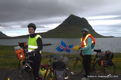 We woke up around 9, had a good breakfast packed our gear and headed out to the road. We started around 11:30. It was cold and wet but the wind was in our back. Today we went through a fantastic landscape with the alpine mountains of Snaefellsnes all around us. My brother Einar and my sister in law Lára met us at Kolgrafarfjörður (they came on their motorbike). After a brief stop at Grundarfjörður we continued onwards to Ólafsvík. Wind was in our back most of the way. It came down as the day progressed and it cleared up. When we came to Ólafsvik my great nephew greeted us and guided us to my brothers home. Waiting us was a feast fit for kings, Fish soup and chicken soup. A warm bath and a hot tube.
 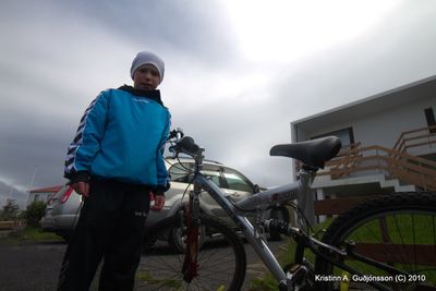 Biked 57 km in 3 hours. Photo 1: The group at Kirkjufell, Photo 2: The guide Árni Daníelsson and photo 3 Lára making soup.
Við vöknuðum klukkan 9 og eftir góðan morgunverð tókum við saman græjur okkar og lögðum af stað. Við hófum ferð klukkan 11:30. Það var kalt og hráslagalegt en vindurinn var í bakið. Við ferðumst um frábært landslag Snæfellsness. Einar bróðir og Lára mágkona komu til móts við okkur á móturhjóli og hittu okkur við Kolgrafarfjörð vestanverðan. Eftir stutt stopp á Grundarfirði héldum við áfram til Ólafsvíkur. Vindurinn var í bakið og mikið hafði rofað til í veðri. Þegar kom til Ólafsvíkur beið okkar 9 ára frændi minn sonur bróður dóttur minnar, Árni Daníelsson, og 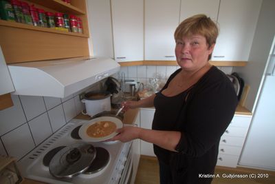 fylgdi okkur á hjóli til afa síns. Hjá Einari og Láru beið okkar konungleg veisla fiskisúða og kjúklingasúpa, heitt bað, og heitur pottur. Við hjóluðum 57 km á 3 tímu. Mynd 1: Hópurinn við Kirkjufell, mynd 2: Árni Daníelsson leiðsögumaður og mynd 3 Lára með súpuna góðu.
Ferðalög | Slóð | Facebook | Athugasemdir (2)
6.7.2010 | 21:15
When I come home to Búðardal – Er ég kem heim í Búðardal
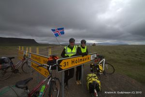
The title of this blog is a line from a pop song which was popular in Iceland som 30 years ago. Well I am in Budardalur after a good ride from Bjarklaundur. We did the 62 km in 4 hours, only on mountain pass on the way which was 240 m.a.s.l. Until we got to the pass we had side wind, calm and head wind but up the pass we had strong tail wind and it kept blowing us the 40 km we had to Budardalur. On the way we past the intersection for the road over the first big mountain pass we crossed more than a week ago. As we past the intersection me and Thelma closed the circle on the Westfjords (photo). Now we have only to go around the Snæfellsnes and then we had to Reykjavík. Statistics for the day are as follows: We cycled 62 km in 4 hours and took 1 hour break. Total ascent was 850 m and the maximum elevation was 240 m.
Þá er ég kominn heim í Búðardal. Reyndar hefur mér alltaf fundist þetta napur og eyðilegur staður. Við hjóluðum framhjá afleggjaranum upp á Þröskuld og lokuðum við Thelma þá Vestfjarðar hringnum (ljósmynd). Hjólatúrinn gekk vel. Frá Bjarkalundi að Skriðulandi vorum við ýmist með logn eða létta hliðarvind. Hins vegar vorum við með nokkuð öflugan mótvind inn dalinn þar til beygir upp Svínadalsháls. Þá var vindurinn í bakið upp brekkuna og reyndar alla leiðina á Búðardal. Borðuðum góðan mat í Leifsbúð en sá staður er eitt af betur geymdu leyndarmálum Bæjarins. Staðsett niður við höfn (í uppgerðu pakk- og verslunarhúsi). Gistum á Bjargi sem er staður sem ég gef ekki eina stjörnu. Sóðalegur og rangar upplýsingar um verð gefnar upp. Forðist þann stað eins og heitan eldinn. Held ég taki frekar neyðarskýlið á Kletthálsi fram fyrir þennan stað. Vistin í Bjarkarlundi var hins vegar flott. Hjóluðum 62 km á 4 tímum. Heildar hækkun 850 m en mesta hæð var á hálsinu við Svínadal.
Ferðalög | Breytt s.d. kl. 23:12 | Slóð | Facebook | Athugasemdir (0)
5.7.2010 | 14:55
The trips statistics so far – ferðin hingað til
I have today biked 697,73 km and have still 397 to do thus making the total trip 1095 km
Mér reiknast til að ég sé búinn að hjóla 697,73 km og eigi eftir 397 km (fyrir Snæfellsnes) þannig í það heila verði ferðin 1095 km
Ferðalög | Slóð | Facebook | Athugasemdir (0)


 vulkan
 bjarnihardar
 thjodarsalin
 gbo
gbo
 loftslag